Rugged Tales

Wherever my feet may take me…


Leave a comment

Size matters

More landslips, and consequently diversions, made for a vexatious start today. Having walked inland on the roads from Lyme Regis we finally regained the beach at Charmouth only to be signposted straight back inland. The brief glimpse of Charmouth’s sea front car park hardly justified the effort of walking out to the coast and back again and I’d have been just as happy to forgo that pleasure and link the two diversions together by staying on The Street instead. I’ll know for next time.

20120716-111219.jpg

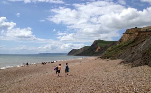
But once we had climbed over Stonebarrow Hill and back to the cliffs I forgot my frustrations in my enjoyment of the views along the coast, spectacular despite the cloudy day. The most prominent feature was Golden Cap, the highest cliff on the south coast of Britain, although – ominously – we also had a clear view of the Isle of Portland in the distance, apparently a sure sign of rain tomorrow.

20120716-150400.jpg

After ten years in Calgary, a stone’s throw from the snow-capped peaks of the Canadian Rockies, Rob was unimpressed with a cliff just 191m high. But when faced with climbing over half a dozen of them in the day I think that small cliffs have their advantages. And, in addition to its height and distinctive two-tone appearance (with a base of dark grey mudrock topped by a triangle of Upper Greensand, a sandstone that turns golden as it weathers) Golden Cap had one other unique feature. In years of walking all around the UK I don’t think I’ve ever seen a double his ‘n’ hers stile before!

20120716-151816.jpg

By the time we arrived in Eype’s Mouth the sun had finally broke through, providing a great view back to the cliffs we’d just walked over.

20120716-153709.jpg

It was so exciting to see the sun for a change I decided to stop in West Bay for a celebratory cream tea. Taking the recommendation of the very helpful couple supervising the Eype’s Mouth car park we headed to Haddon House Hotel, which they told us served one of the best cream teas they’d ever had. It came on a ceremonial tray, doily-topped plates nestled on a bed of deep red napkins: undoubtedly the best-presented of the trip. But, while tasty, it wasn’t quite a prize-winner – the side plate of chocolate biscuits added variety but I would have traded it for a second of the lovely but rather small scones, and a larger pot of tea.

From West Bay there was just one more cliff to climb before our campsite at Burton Freshwater. Where my scone had been a little small, the camping pitch I’d booked turned out to be enormous. Promised “a small walkers pitch just big enough for a two man tent” the spot we were allocated would easily fit ten tents the size of mine. It makes me wonder just what equipment the other backpackers in this area are using…


Leave a comment

Slip slidin’ away

My boots aren’t the only thing slipping and sliding after all the heavy rain. The geology of the cliffs on this part of the coast makes them particularly unstable and prone to landslips. We had already walked through Hooken Undercliff, the result of an 18th century landslide, on our way into Beer yesterday. Barely a mile further on from last night’s campsite we came upon a more recent landslip to the west of Seaton. The day before, a section of the Old Beer Road had dropped by a metre after the cliff in front of it slid down to the beach.

20120715-205441.jpg

The road has been closed to vehicles indefinitely and the Coast Path is apparently being diverted. At the time we passed, however, the signs had not yet been put up and the only diversion we were aware of was to the pavement on the other side of the street. We shared it with a host of equally clueless and/or curious bystanders, all gazing with eager interest at the chasm in the Tarmac, until it occurred to me that where one bit of cliff had gone some more might follow. We hurried down to the safety of the town and it’s solid promenade – at sea level by design.

But the majority of today’s walk was based around another historic landslip: the Axemouth – Lyme Regis Undercliffs. Now an 800 acre National Nature Reserve, the Undercliffs were formed when around 8 million tons of soil and rock slid down the cliffs on Christmas Eve 1839. Originally farmland – the crop of wheat and turnips that had been planted before the slip were harvested in celebration the following summer! – the area is now dense woodland, and extremely muddy. A lady we met in Beer, who holidays in the area for several weeks each year, told us it normally took her two and a half hours to walk to Lyme from Seaton. After negotiating countless steps and picking our way over tree roots in the thick slippery mud it took us nearer four. But it could have been worse. We passed numerous trees that had fallen over the pathway, presumably victims of the recent wind and rain. The sawdust from their removal was still fresh on the path; if we’d come past a few days ago we might have had some additional obstacles to our progress.

20120715-212430.jpg

Keeping our balance in the mud while carrying large backpacks was exhausting – and not wholly successful. Surprisingly, given that I’m generally acknowledged to be the clumsy member of the party, it was Rob who slipped on the steps, possibly because he’d chosen a less than ideal moment to take off his sunglasses. As he put down his hand to break his fall the glasses he was holding were caught in the action and it looked at first as though they’d been critically injured. But fortunately, after a good wash and some minor repairs, both the sunglasses and Rob emerged from the accident perfectly functional, if a little more scratched than before.

It was a relief to reach Lyme Regis and the bliss of a metalled road. But the landslips weren’t finished with us yet. On leaving the town the Coast Path has been extensively diverted to avoid a whole series of them.

20120715-215341.jpg

But having seen what’s happened at Seaton this week I was just as happy to be camped a mile or two inland, just to be on the safe side!