Rugged Tales

Wherever my feet may take me…


2 Comments

I came, I saw, I ran away as fast as I could

My private campsite last night was so lovely and peaceful, and I was so tired after a tough day, that I didn’t wake up until after seven. So much for an early start! And it promised to be another long day. My guidebook suggested spending a night in Plymouth, but since Plymouth isn’t big for camping I decided to try and compress three of the book’s stages into two so I could camp either side of it. Today was the second of those days, and an even greater distance than the first one, but at least I was lucky with the weather. It was still very windy but sunny with it, and much clearer than yesterday. When I first arrived back at the cliff top from my campsite in the valley I was amazed by the view back around the bay, and by how close Rame Head had got under cover of yesterday’s mist and low cloud!

But one thing I didn’t see all morning was Plymouth. By virtue of the shape of the coast, and the routing of the path through some dense woodland, it remained hidden until the last minute before being dramatically unveiled close as if at the conclusion of some giant conjuring trick. I boarded the ferry at Cremyll to close the last part of the distance, and so left Cornwall behind after some 280 miles of coastline.

In addition to being momentous, it was an unusually exciting ferry ride. A Spitfire flying low over the city in loop-the-loops and barrel rolls elicited oohs and ahhs from all the passengers. But arriving at Admiral’s Hard I came down to earth with a bang. After weeks of walking alone on remote cliffs, during which I’d come to view places like St Ives (population ca 12,000) and Penzance (population ca 30, 000) as big centres, Plymouth (population ca 260,000) was a shock to the system.

A huge amount has been done to make the route through the city attractive and interesting, and I enjoyed the redeveloped Royal William Yard, and the Sherlock Holmes quotes set into the pavement of Durnford Street (where Arthur Conan Doyle once lived). But the signage – though striking when I found it – was sporadic, and even the guidebook gave faulty instructions at one point. Thank heavens for Google Maps, or I’d probably still be wandering hopelessly around Millbay Docks!

20120701-094219.jpg

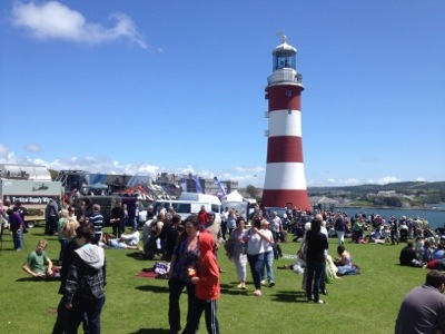
As I approached The Hoe the crowds were denser than I expected, even for a sunny summer Saturday. Stopping to read a ‘road closure’ sign I realised I had unwittingly walked into the middle of Armed Forces Day. In hindsight, the Spitfire thing probably should have tipped me off… It looked like a fantastic family day out, and a great way to celebrate the contribution of the many men and women who serve our country. But the noise and the crowds were too great an assault for my senses. When Johnny Vaughan took the microphone and informed the crowd that there would be an opportunity later to meet Justin Bieber, the ear-piercing shriek from a young woman standing next to me (who, frankly, looked a bit old for him) was the final straw. I abandoned my attempt to admire Smeaton’s Tower, and fought my way back to the road.

20120701-094437.jpg

I stood in front of the Royal Citadel to get my bearings until I realised that the guns that we’re about to fire a salute were directly over my head. Hastily retreating towards the marina I instead watched a so-many-guns-I-lost-count salute from a ship sailing by. Unfortunately, having an almost no knowledge of the Navy other than that it exists, I can’t tell you what ship it was, or even what type, only that it was very large and grey. If any of my better-informed friends knows then I would be grateful for the instruction! I feel somewhat embarrassed by my ignorance, especially having grown up within 20 miles of Portsmouth, and am resolved to educate myself a little when I get back.

But for today, the boat I was most interested in knowing better was the Mount Batten ferry. A lengthy battle with the crowds in the Barbican to buy so much as an ice-cream had crushed the last of my interest in seeing more of Plymouth today, and my only thought was how to effect the speediest escape. Although I missed out 5 miles of the Plymouth Waterfront Walkway by catching the ferry, I’ve added on that many extra miles in the last few day alone going to and from campsites, and there seems to be no logic I can follow about when a ferry is an established part of the route and when you’re supposed to walk round. I decided the ‘cheat’ was not such a heinous one, under the circumstances.

Even with the shortcut I’ve covered 40 miles in the last two days, and am quite tired as a result. Luckily, the end of the day proved a perfect restorative. At Mount Batten the crowds immediately fell away and from there to Wembury was a peaceful, relaxing walk over generally easy terrain, with some great views back towards the city from a suitably safe distance.

20120701-094548.jpg

A sign at Wembury Beach gave the distances to Minehead and Poole. I can’t quite believe that there are ‘only’ 206 miles left to go! But I’m relieved none of them are likely to be as densely populated as today’s.

20120701-094733.jpg


Leave a comment

Exposed

It’s ironic that I should find myself on one of the most exposed campsites of the trip on one of the windiest nights. High on a hill-top above Polperro, the site had panoramic views of the surrounding countryside, but there was not so much as a small bush between my little tent and the howling gale. It was a noisy – and slightly anxious – night, but happily the tent and I emerged unscathed and set off towards Looe.

The hills were starting to get quite steep and I was entertained by the sign at the bottom of one slope. The photo doesn’t do the gradient justice; I would be hugely impressed if anyone could cycle up that incline, even without the steps!

20120630-213108.jpg

I arrived in Looe at lunchtime and since this would be my last full day in Cornwall I sought out one last ‘farewell’ pasty. Or, more precisely, two: a prize-winning bacon, cheese and leek (fully deserving of its laurels) and a slightly left-field rhubarb, apple and custard, which I put in my pack for later. Two pasties at one sitting was a bit much even for me.

And I wanted to leave room to check out one last Cornish ice-cream. Treleavens has a sizeable number of outlets across the South West, but are based in Looe. With more awards than any other Cornish ice-cream producer it would be rude to leave the county without sampling their wares, right?! It was very tasty but my enjoyment was marred by my decision to eat it as I walked. I hadn’t realised that the Coast Path out of Looe went up quite such a steep hill. It turns out even the best ice-cream can give you indigestion with enough exertion during its consumption!

The initial ascent out of Looe wasn’t the only thing the guidebook didn’t properly prepare me for. The three miles between Looe and Seaton were a total roller coaster, and I started to doubt whether I’d have the stamina to get to the campsite I was aiming for. Fortunately, although the path subsequently went over a couple of the highest cliffs in the area, it went up and stayed up – unusually for the Coast Path – before dropping down to thd fabulously named Portwrinkle.

20120630-220635.jpg

That just left the weather to deal with. It was a cool, grey day and high up on the cliffs I was continually buffeted by the full force of the wind. By Portwrinkle I felt I’d earned the desert pasty! From there it was still another couple of chilly, wind-swept hours, across the MoD training area at Tregantle to Tregonhawke, the last campsite I could find before Plymouth. Although I chose it purely for its location, turned out to be one of my favourite camping spots of the trip. Not a campsite proper so much as a standing permission by a friendly farmer for Coast Path walkers to camp by the side of his fishing lake, it had only a toilet and a drinking water tap by way of facilities. But I was happy to forgo some creature comforts to have such a lovely spot all to myself for the night.

20120630-222554.jpg


Leave a comment

Paradise regained

‘Here we go again!’ I thought, emerging from my tent to find everything wreathed in fog. Happily, I got a reprieve from having to go out in it by the discovery that there were no laundry facilities at the next two campsites. With an urgent need for clean pants and socks, it was clearly imperative that I do my washing before I left – and drink tea and eat biscuits while I waited! But eventually there were no more chores to do and nothing for it but to start walking.

It looked like it might be brightening up, and I’d not been going 10 minutes before I had to stop and rummage in my pack for my shades and my sunscreen. It felt like an age since I last needed them! And as I walked down the lane away from the campsite a wonderful view opened up across the fields and down to the sea: quintessential English countryside, complete with the tiny Tregaminion church. Who knew that was there?! I started making my way round Gribbin Head, and was quite startled by the views back across the bay to St Austell. There were the massive spoil heaps from the china clay works, the factories and the docks. If I hadn’t have read about them in the guidebook I’d never have suspected their existence yesterday. As it was, they were much more extensive than I’d imagined.

It turned into a glorious sunny day, and though the paths were still muddy and overgrown the fresh breeze, and the late start, had dried out the grass. That alone made it a huge improvement on yesterday and in some places, like the area around the enormous Gribbin Head day tower, the going was refreshingly easy.

20120629-144712.jpg

I didn’t expect it would remain so, however; the seven mile section from Polruan to Polperro was reputed to be particularly tough. I fortified myself with a pasty in Fowey, admiring the unusual knitted decorations all around the harbour railings as I ate, then caught the ferry across to Polruan to run the gauntlet…

20120629-144757.jpg

It was fantastic fun! It’s true there were more, and steeper, ascents and descents than on previous stages, but it was still nowhere near as tough as the roller-coaster cliffs on the North coast. The paths were mostly clearer and drier, and the terrain much more open so the spectacular scenery was in view most of the time.

20120629-144844.jpg

It was a world away from the thankless trudges through a sodden overgrown strip between a high hedge on the seaward side and a farmer’s field on the other that have characterised the last few days. As I strode along the remote paths, drinking in the views I remembered why I wanted to walk the Coast Path – and fervently hoped the worst of those ‘jungle paths’ are behind me now.


Leave a comment

Misty moisty morning

The fog this morning was almost as thick as yesterday, and the forecast even worse. But since I had already established, like so many others before me, that the weather forecast and what actually happens bear little relation to each other in Cornwall I started walking and waited to see what happened. Walking in the fog was a strange and unsettling experience. I don’t normally feel afraid, even when walking alone in remote areas, but with the fog concealing who or what was out there I felt surprisingly nervous. Continually peering round me into the gloom I was still startled by the unexpected appearance of another person on the path, or in one case by the emergence from the murk of an entire headland!

The other thing I quickly grew to dislike about the fog is how it clings to the vegetation. Every blade of grass drooped under the silvery weight of water droplets – droplets that were readily transferred from the grass to the tops of my socks, and from there down into my boots. Five minutes after leaving the campsite I could feel the water creeping down round the sides of my feet; after an hour of pushing through the wildly overgrown paths I had to stop and pour the water out of my boots, so unendurable was the squelching – and the extra weight. And that was before it started to rain.

20120628-085645.jpg

It was only a couple of hours to get from my campsite back to Gorran Haven and on to Mevagissey, but that was two too many. By the time I arrived in the town I must have looked downhearted as well as very wet; I walked into a shop to be greeted with “Oh, you poor thing!”. But in Mevagissey I found two things to lift my spirits: a travel size tube of toothpaste (just as mine was running out and I feared I might have to carry a full size one around) and some wonderful handmade fudge. Best of all, as I left the fudge shop chomping on a particularly tasty piece of their ginger variety, I found it had stopped raining.

And I needed all the encouragement I could as I fought my way through the paths after Pentewan. Tripping on branches and tangled tussocks of long grass, slipping on the slick sticky mud, a couple if times I came within a whisker of falling over. But I wasn’t the only one struggling with the conditions. As I passed one field of cows a particularly friendly one came running across the field towards me, only to find her attempt to brake on the slope down to the fence turned into a high-speed skid. For a split second our eyes met in a shared moment of mutual terror. I didn’t figure that a few strands of barbed wire would save me from half a ton of cow moving at speed. Happily, at the last second she regained traction and we never had to put it to the test, but it was a close call!

20120628-092404.jpg

Shortly afterwards there was more good luck: in the woods round Hallane, I finally found some paths that had been strimmed back. I was almost more relieved by that than the near miss with the cow! Free at last to look around, there still wasn’t much to see through the heavy fog. A glimpse of what was probably a very attractive rock arch, if I’d been able to see it clearly, was as good as it got.

20120628-092936.jpg

After all the challenges of the terrain on such a damp, gloomy day, I was uncharacteristically happy to finish the day on Tarmac. The historic harbour at Charlestown, little changed from the 18th century with its rows of old cottages and tall ships, was easy to like.

20120628-093853.jpg

But as I skirted St Austell, I found that even the A3082 into Par had a certain qualities I was for once fully able to appreciate!


5 Comments

Humbled

I emerged from my tent this morning to fog so thick I could barely see 20 yards. Since a key feature of walking the path is the stunning views I dawdled about the campsite hoping it would clear as the day warmed up, but it was just as thick at 9:00 as it had been as 7:00. I ummmed and ahhhed and eventually decided that, since it wasn’t actually raining, I really ought to walk. To that end I went over to the washblock to retrieve my boots from the drying room, donned them and strode confidently out towards the tent…and into pouring rain. I just couldn’t face two soakings in as many days and decided there and then to take the day off.

Having eaten all the food I’d bought with me yeaterday I was glad when the rain stopped after a bit so I stayed dry as I walked into Gorran Haven for supplies. A lovely small village with a little beach and tiny harbour I was surprised to see it had as many as three (small!) churches. But the most interesting sight for me was the purported 16th century smugglers cottage.

20120626-194137.jpg

In half an hour I’d seen all the village sights. What to do with the rest of the day? If I’d been there tomorrow I might have attended the Mevagissey Ladies’ Choir concert!

20120626-194508.jpg

As it was, I had no other option but to head to the village cafe for a cream tea. Though not able to knock Falmouth from the top spot it was nevertheless enjoyable, and the first to use a scone with sultanas: a bold but successful innovation! It also introduced me to Cornish tea, as in tea actually grown in Cornwall. I’d had no idea that there was a tea plantation in the UK, so Tregothnan tea came as a complete surprise. But it had a distinctive, light flavour I really enjoyed; I plan to mail order a stock when I get home!

Exiting the tea shop my attention was caught by two cars in matching orange ‘Spaceships’ livery. Spotting a poster in the rear window of one I snuck over to have a look. They turned out to be the support vehicles of two guys (one Brit, one Kiwi) who have set out to run the entire Coast Path in a fortnight to raise funds for, and awareness of, mental health issues. That’s the equivalent of running one and a half marathons every day for a fortnight, which would be impressive enough on smooth, flat roads but I’ve seen first hand the terrain they have to cover. For all my complaints about the weather, and the mud, and the overgrown paths, I am fundamentally walking the Coast Path because I enjoy it. But I can’t imagine enjoyment is anywhere on these guys’ radar. I had a great conversation with Phil, one of the support drivers, while he waited for the runners to arrive for some food, water and ice for their injuries. As they came into view I left them all to it, humbled by the pain they are prepared to endure for a cause about which they clearly care deeply, and the magnitude of their achievement compared to my own modest effort.


Leave a comment

Disappointment

I thought about taking the day off today: when planning the trip I’d allowed myself one a week. But bright sunshine woke me at 6am, and with the Met Office optimistic about the weather I decided it was too good a day to waste. In happy anticipation I donned my shorts, applied my sunscreen and hit the road.

I walked back down into Portscatho to buy something for lunch, then set off round Gerrans Bay to Nare Head some four or five miles away. By the time I got there clouds had crept overhead and it had started to rain a little. Perhaps it was just a shower.

Two hours later and it was still raining on and off, and increasingly on. So much for sunscreen! Growing weary of being rained on, the idea of an indoor lunch snuck into my mind as I approached the pretty village of Portloe.

20120626-094457.jpg

My guidebook mentioned a tea room there and I walked up and down the main street looking for it. I found a smart hotel and a pub, but no tea room. I asked three people if they knew where it was but none of them was from the village and no-one had seen it. Not in the mood for heavy pub food – and not suitably attired for the hotel! – there was nothing for it but to press on and find consolation in my hardiness.

After a slightly damp picnic on a pile of fallen rocks (the driest available surface to sit on) I carried on to Portholland, where my guidebook said there was a cafe. There was a building that looked as if it might, at one time, have served refreshments…but not today. Portholland did, however, have some fabulous public toilets maintained by a local volunteer – some of the most stylishly decorated I’ve ever visited.

20120626-095020.jpg

By now it was raining heavily. Musing on how a forecast of “dry with sunny intervals” could translate into a whole afternoon of heavy persistent rain, I set off for Porthluny Cove where the guidebook claimed there was one last cafe. By now I figured I had more than earned a pot of tea and a slice of cake in a cosy eatery. But when I got there it turned out to be more of a beach kiosk – foiled again!!

Clearly, I was not fated for cake today. I took a last look at the imposing Caerhays Castle through the rain and set off again. Since it looked like the best I could hope for was half-packet of fig rolls and tea in my tent, the quicker I got to the campsite the better. But I was not going so fast that I couldn’t stop to admire the misty views from Dodman Point, and the huge granite cross on the cliff edge.

20120626-095035.jpg

I sent up a quick prayer for better weather, and headed off to Treveague Farm campsite. That at least did not disappoint. With toasty hot showers, Roskilly’s ice cream (my favorite!) on site and – best of all – a drying room, it was an earthly paradise for a damp hiker. But as I sheltered in my tent from another evening of torrential rain it didn’t seem that my weather prayers had been answered. Maybe tomorrow…


Leave a comment

Messing about in boats

I thought I might be needing a lifeboat last night, it rained so hard! But by the morning the wind died down, the rain slowed to a light patter, then stopped, and I ventured outside the tent. I’d pitched in the most sheltered location I could as protection from the strong winds, but that was also the lowest – and now wettest – point in the field. Fortunately, my tiny tent fit on top of a slight mound and thus stayed dry underneath where pools of water had formed on the grass all around – it put me in mind of Ely cathedral in the middle of the flooded Fens! Although it was a soggy experience getting in and out, not everyone was displeased with the state of affairs; as I ate my breakfast a blackbird made use of the puddle nearest my door as a bird bath.

20120625-091841.jpg

I waited until the last few showers had died out then packed up my gear and set off for Falmouth. Although I’d already visited the town yesterday I’d gone by the direct, inland route – and by motor vehicle. The Coast Path, which goes all the way round Pendennis Point, was a lot further but full of interest. As the last of the clouds burned off to reveal a fine summer day, I passed several attractive beaches and got fine views of Pendennis Castle before skirting Falmouth Docks. I hadn’t appreciated before the scale of operations there – and was astounded at the size of some of the container ships!

20120625-091927.jpg

Passing the faded grandeur of streets of Victoria villas I arrived outside the museum. In a brand new development in sharp contrast to the industrial docks and the adjacent residential district, the museum sat on one side of a wide plaza enclosed by smart eateries. I didn’t have time to go inside, but it seemed like as good a place as any for lunch.

As I sat on the plaza steps eating my Rick Stein takeaway fish and chips (very tasty) Jillian’s husband Jim walked up. Jillian had stopped in Helford yesterday as the low tide had stopped the ferry, and he was waiting to meet her in Falmouth later that afternoon. It was lucky I bumped into him because it turned out that, just feet from where we sat, a remarkable concentration of J class yachts were moored in preparation for a regatta next week. I’d passed by the marina, and noted the large number of boats but – not being a sailor – had totally failed to appreciate that some were pretty special. Once my attention was drawn to them, however, I could see why any discerning Prince or Sheik might want one! (They’re the ones on the right for any other yacht dummies like me.)

20120625-092010.jpg

From there it was just a short stroll up to the quay to catch the less costly and less beautiful – but more practical – St Mawes ferry. It took about 30 minutes to cross and it was perfect weather to be on a boat. I clearly wasn’t the only one who thought so: everywhere I looked were yachts racing, ferries crossing and a myriad of other craft on unknown missions. The harbour at St Mawes was lovely too but I didn’t have much time to appreciate it before hopping onto the next ferry to Place.

20120625-092124.jpg

After all that boating it was quite a shock to have to walk again. But the stroll round St Anthony Head, through the old fortifications that (together with those I saw on Pendennis Point and by St Mawes Castle) helped defend this huge natural harbour, and up to Portscatho was a pleasant one and not too demanding. And I think I saw one of those gorgeous J class yachts sailing along off the shore beside me as I went.


2 Comments

Maslow’s hierarchy

A mile into today’s walk I reached Porthallow – 315 miles from Minehead and the half way point of the Coast Path. Described by the Falmouth Packet, when a new Coast Path monument was unveiled in 2009, as an ‘enormous psychological moment’ for those walking the whole path, I’d been eagerly anticipating this important milestone. When the moment came, however, I forgot all about it.

Looking back I attribute this to Maslow’s hierarchy. I had spent the night at the Porthkerris dive centre, which has a pleasant, quiet camping field at the top of a cliff….and showers and toilets at the bottom. Faced with a 15 minute round trip down and then back up a very steep road to use the facilities, and with a long day ahead, I decided it would be more efficient to just start walking along the path. In 20 minutes or so I would reach Porthallow and could use the public conveniences there instead. By the time I arrived in the village my desire to find those facilities, and relief in succeeding, totally eclipsed any thought of the half-way point!

With that over, my focus moved up the hierarchy a little, but only to the practicalities of the day’s walk. From Nare Point I had a good view of the two inlets I needed to cross by ferry – Gillan Harbour (on the left of the photo) and Helford River (on the right) – to get to Falmouth.

20120624-092916.jpg

The Helford ferry details I already had from their website but the Gillan Harbour service had only a phone number. Deciding 8:30am wasn’t too early to call, I enjoyed a second wave of relief before I left Porthallow when the gentleman I spoke to confirmed the Gillan ferry would be running from 9:00. I set off happily and it was only after another hour of tricky, muddy, overgrown paths when I was safely on his little boat that I remembered about the halfway marker. By that point I wasn’t going back for it!

After another hour or so if walking I arrived at Helford, opened the sign to show it’s orange innards to the world, and settled back to wait for the ferry to arrive.

20120624-094353.jpg

Twenty minutes later it did, requiring a conscious effort on my part to relax on the quayside when both my London conditioning and my desire to get to Falmouth before the shops shut made me chafe at the delay. Even after all these weeks I still find myself surprised – though ultimately pleased – by the slower pace of life.

But I wasn’t pleased today! With the next major shopping opportunity not until St Austell (four or five days away) and my need for supplies acute, I pressed ahead and made excellent time, hitting Swanpool Beach on the outskirts of Falmouth just after 2pm. Even with some frustrating backtracking after discovering the nearest campsite to the path had been sold for a housing development, I had time left over after my errands were run. What better way to spend it than sampling the cream tea in de Wynn’s famous tea shop?

20120624-095716.jpg

Not a lot I would hazard: my Falmouth cream tea has leapt in at the top of the charts. Light tasty scones with a mushy jam that was mostly strawberries and tea served in an old-fashioned rose-patterned tea service, it was as charmingly presented as it was delicious. The traditional tea room ambience came complete with a soundtrack of crooners, and its location provided a fabulous view over the harbour. Add in a team effort from two waitresses, the lady – a regular – at the table behind, and a couple at the table next to me with a copy of Falmouth’s tourist transport guide, all helping me work out where the number 500 bus back to the campsite would leave from, and it was undoubtedly my best all-round cream tea experience so far. As another storm moves in and I’m huddled in my tent with my little burner struggling to heat my dinner in a strong wind and heavy rain, it’s good to have the memory of it to help cheer me up!


Leave a comment

Slippery when wet

Overnight the breeze freshened, and strengthened some more until the darkness was saturated with the rush of wind through the trees, the snap of the fly sheet with each gust and the pounding of the rain. It wasn’t the most peaceful night I’ve ever spent under canvas, though it had the benefit of obliterating the sound of the snorer in the tent next to me! But by breakfast time the rain had stopped leaving a bright and breezy day ahead.

I started out by rounding Lizard Point. How different it looked in the sunshine today compared to yesterday’s lashing rain!

20120622-213715.jpg

Energized by the glorious start I bounded off round Housel Bay looking forward to the day’s hike. But I hadn’t allowed for the aftermath of two days of heavy rain, or the local terrain. The first had left large parts of the path a sticky, slick mess and I realized how much harder it is to get up and down the steep narrow cliff paths with limited traction. The second meant that in between the mud weren’t normal rocks – oases of firmness on which a walker could confidently step to avoid the quagmire – but rather the Lizard peninsula’s own special serpentine. I’d been primed to appreciate this particular rock, as an interesting geological phenomenon and as an attractive material for local artisans to work into souvenirs. But no-one warned me that it is surely the slipperiest rock known to man. Even with relatively clean, dry boot soles I was apt to slip straight off if I stepped on a lump of it, and if any trace remained from one of the (numerous) muddy patches the result was a frictionless interface that put Teflon in the shade.

With much of the Lizard peninsula formed of serpentine there were plenty of rocks to slip off. The difficulty was compounded on the headlands by the strong winds, in which it was sometimes difficult to keep my balance even with a firm footing. But the lowest point came on the badly maintained paths after Kennack Sands. The Coast Path has already supplied steep paths, muddy paths, rocky paths, waist high vegetation and low overhanging branches, but not – until today – all at the same time. And not combined with a generous quantity of super-slip boulders to clamber over.

20120622-220717.jpg

If took me three hours to cover the four and a half miles from Kennack Sands to Coverack, and by the time I had laboriously slipped and tripped my way to the village I was ready to quit walking the Coast Path and get the next train home.

But the views of the beautiful harbour cheered me up, as did the knowledge that halfway along Coverack beach lay the transition zone between the serpentine (from the Earth’s mantle) and gabbro (from the Earth’s crust). Coverack is one of the few places in the world where the ocean crust and the mantle are exposed on the Earth’s surface, making it a Site of Special Scientific Interest and a favorite destination for geology student field trips.

20120622-222053.jpg

But my primary thought was that gabbro couldn’t fail to have a better grip than serpentine. I shot round the bay like a (rather tired) greyhound out of the traps, and the new rock more than lived up to my expectations. The path after Coverack was quite marshy in places but I sprang from stepping stone to stepping stone, reveling in the sure-footed security of a nice bit of basalt. I’ll sleep easier tonight knowing that’s one ordeal that’s behind me now: serpentine thankfully isn’t found anywhere else in England!


Leave a comment

Mud and puddles

Last night was an anti-climax weather wise. Braced for torrential rain and strong winds, mere fog and drizzle were rather a let down, although there was one hairy moment during a nocturnal trip to the wash block when I couldn’t find my way back to the tent in the murk. Luckily, I spotted my footprints from the out trip in the dewy grass and followed them back to my bed. When I woke in the morning there wasn’t even fog, just a still, grey but dry – at least for the moment – day. However, the Met Office forecast (for what it was worth) predicted heavy rain starting late morning. Thus motivated, I leapt out of bed (well, wriggled – it’s a small tent), packed up my gear as fast as I could and hit the road within the hour.

Having covered extra ground yesterday it was a relatively short distance to Lizard, the end of the next stage, and I figured that if I could reach it I would both avoid losing a day to the weather and have better facilities for a wet day than a campsite in the middle of nowhere – however nice – could offer. With all the extra distance I’d done yesterday I felt justified in heading to the nearest point on the path rather than backtracking to Mullion Cove, and from there I set off towards Lizard Point as fast as I could. Unfortunately, that wasn’t very fast. The path had not been improved by hours of heavy rain and snaking round the puddles and slipping on the slick mud – which nearly had me over a few times – slowed my progress considerably.

20120621-212012.jpg

But eventually Kynance Cove came into view with it’s particularly attractive stacks, one of which is intriguingly called Asparagus Island!

20120621-212340.jpg

At low tide the Coast Path drops down to the beach at Kynance Cove and initially I was pleased to have a break from the mud and puddles. But between the unstable rocks and piles of seaweed it proved to be even more treacherous. After several near tumbles I was relieved to regain the relative security of a muddy path up the cliff on the other side!

But if the rain wasn’t good for me it was great for the plant life. I saw the biggest wild mushrooms I’ve ever seen in the UK on the cliff top above Pentreath Beach.

20120621-213631.jpg

Even more exciting, I saw a family of Cornish choughs – rare birds that have only recently returned to Cornwall. I also saw them around Cape Cornwall so I’ve been really fortunate in that regard.

But a little after 10am, as I was approaching Lizard Point, it started to rain again. Anxious to avoid another soaking I abandoned my plan of walking as far as the lighthouse and headed straight for Henry’s campsite. It felt strange to be pitching my tent, rather than striking it, at that time in the morning but at least I got it up before the heavy rain started. With the rest of the day to spare I took the opportunity to do my laundry, and as I waited for it to finish, sharing the barn with an eclectic selection of naughty chickens raiding the feed bin, I could hear the rain pouring down harder and harder outside.

Happily, Lizard provided a great selection of places to hide from the weather for such a small place. And when the rain eased off a little in the late afternoon I even made it down to the Polpeor Cafe on Lizard Point – Britain’s southernmost cafe – to sample their cream tea: purported to be the best in town.

20120621-221018.jpg

It was certainly the most filling so far, with two huge scones! It was touch and go whether I could manage my dinner after that. But after all this walking there seems to be no limit to the amount of food I can put away. For all that I hope there aren’t too many more days this wet: I’ll be both broke, and as round as a football by the time I get home!